Sikuttiaq – Sea ice travel safety, Inuit Qaujimajatuqangit, sea ice monitoring
Project overview
ᐱᔪᓐᓇᕐᓯᓂᕐᓴᐅᖁᓪᓗᒋᑦ ᓄᓇᓖᑦ ᓇᓗᓇᐃᕐᓯᒪᔪᓂᒃ ᓄᓇᖑᐊᒃᑯᑦ ᒪᓃᑦᑐᓂᒃ ᐊᒻᒪᓗ ᖄᒥᓯᒪᔪᓂᒃ ᐊᑦᑕᕐᓇᖏᑦᑐᒃᑯᑦ ᐃᖏᕋᓂᕐᓴᐅᖁᓪᓗᒋᑦ ᓯᑯᒃᑯᑦ ᐃᓄᐃᑦ ᓄᓇᖏᓐᓂ Empowering our communities to map rough ice and slush for safer sea-ice travel in Inuit Nunangat
Donner à nos communautés les moyens de cartographier la glace rugueuse et la neige fondue afin de renforcer la sécurité des déplacements sur la banquise dans l’Inuit Nunangat
Hakugighaiyut nunallaarnik nunauyaliuriamik maniilruqnik hikumi hikuilruniklu amirnaittumik hikumi-aullaariamik Inuit Nunanganit
ᐱᔪᓐᓇᕐᓯᓂᕐᓴᐅᖁᓪᓗᒋᑦ ᓄᓇᓖᑦ ᓇᓗᓇᐃᕐᓯᒪᔪᓂᒃ ᓄᓇᖑᐊᒃᑯᑦ ᒪᓃᑦᑐᓂᒃ ᐊᒻᒪᓗ ᖄᒥᓯᒪᔪᓂᒃ ᐊᑦᑕᕐᓇᖏᑦᑐᒃᑯᑦ ᐃᖏᕋᓂᕐᓴᐅᖁᓪᓗᒋᑦ ᓯᑯᒃᑯᑦ ᐃᓄᐃᑦ ᓄᓇᖏᓐᓂ ᑎᒍᓯᕙᓪᓕᐊᓂᖅ ᓄᓇᑦᑎᓐᓂ ᓄᓇᓐᖑᐊᓕᐅᕐᓗᑎᑦ ᓯᑯᓐᓂᑦ ᐊᕿᑦᑐᐊᓗᓐᓂᓪᓗ ᖃᐅᓯᕈᔪᐊᓗᓐᓂᑦ ᐊᑦᑕᓇᖅᑐᒦᖁᓇᒋᑦ ᐃᖏᕐᕋᔪᑦ ᐃᓄᐃᑦ ᓄᓇᖏᓐᓂ
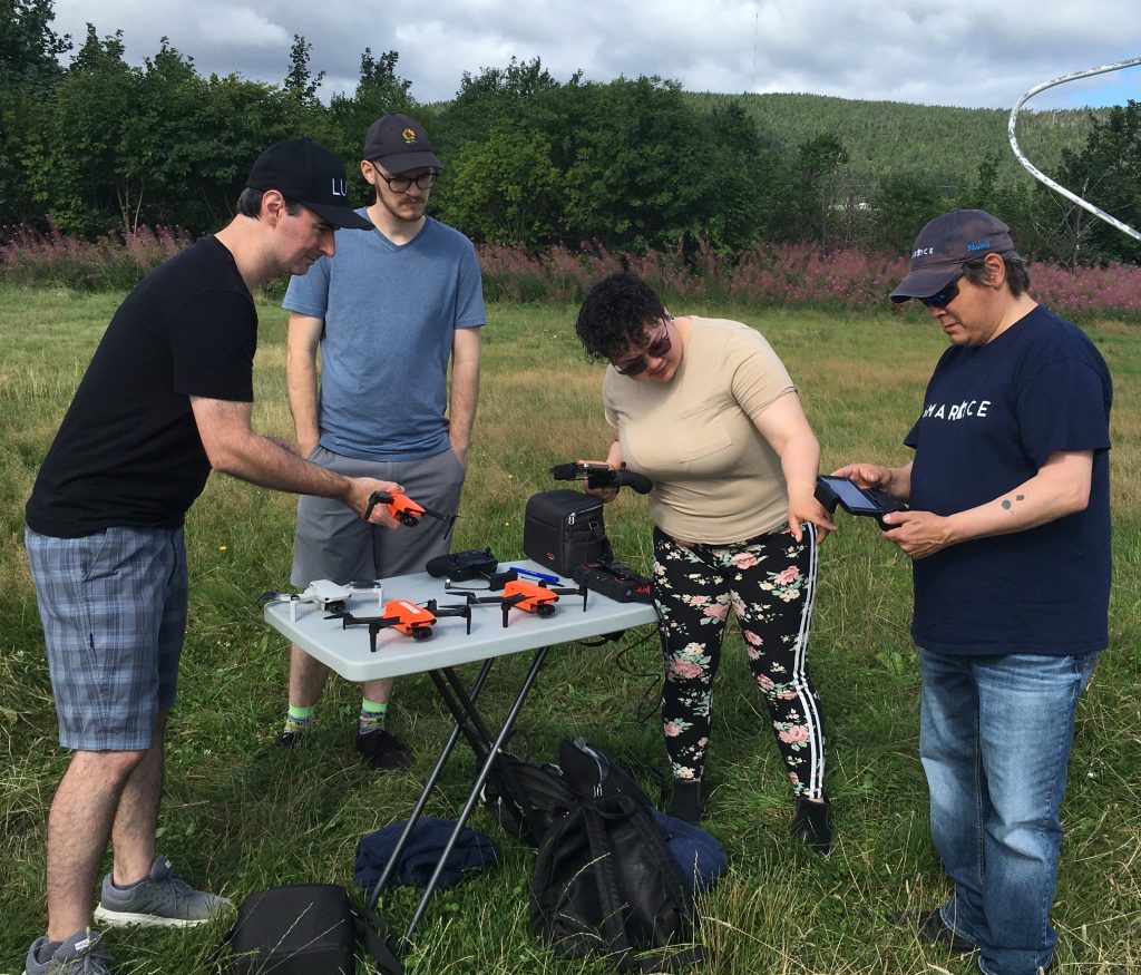
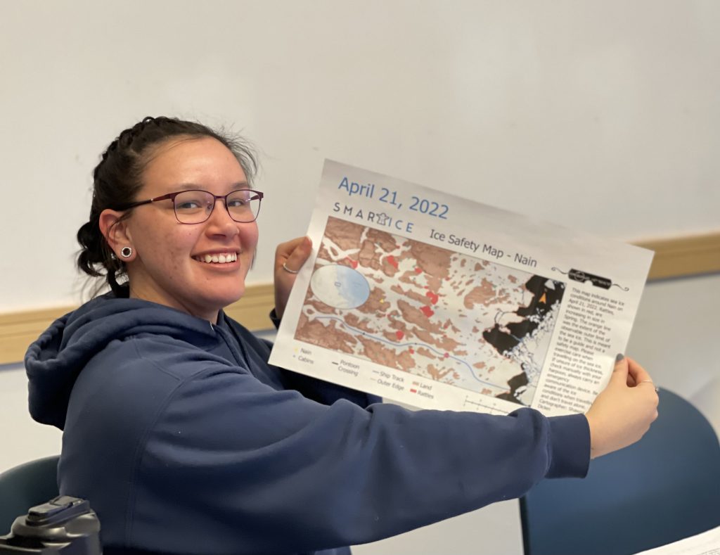
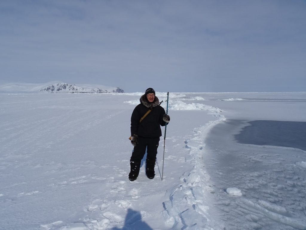
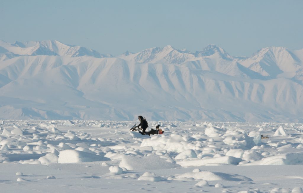
Sea-ice roughness, thickness and slush are key characteristics that determine safe and efficient ice travel for Inuit. The changing climate is negatively affecting these characteristics, impacting mental health, food security and cultural practices. Our Inuit-led project team will combine satellite and drone sensor data, with Inuit Qaujimajatuqangit to generate new data layers for community ice travel safety maps (SmartICE’s Sikumik Qaujimajjuti).
The following two videos provide further information about the project and also about SmartICE, the lead organisation for Sikuttiaq:
Project location
Nunavut and Nunavik regions
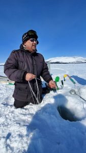
Helping to keep my community safe when they travel on the ice is very important to me and I am very proud that my community trusts me to provide the SmartICE ice monitoring and mapping service for them. They have been noticing that the ice is changing and becoming less predictable, with more rough ice and slush. The Sikuttiaq project will generate more ice mapping tools and information that me and my SmartICE colleagues can use to help our communities manage these added travel risks.
Andrew Arreak
Principal Investigator, SmartICE Sea-ice Monitoring & Information Inc.
I feel privileged to work on this Inuit-led project and provide useful information from space on the sea ice conditions (roughness & slush) in the locality of Pond Inlet. I am excited to see the potential for this pilot project that combines Inuit knowledge with state-of-the-art remote sensing techniques to support safer travel in the rapidly changing landscape of the wider Inuit Nunangat region.
Michel Tsamados
Principal Investigator, University College London
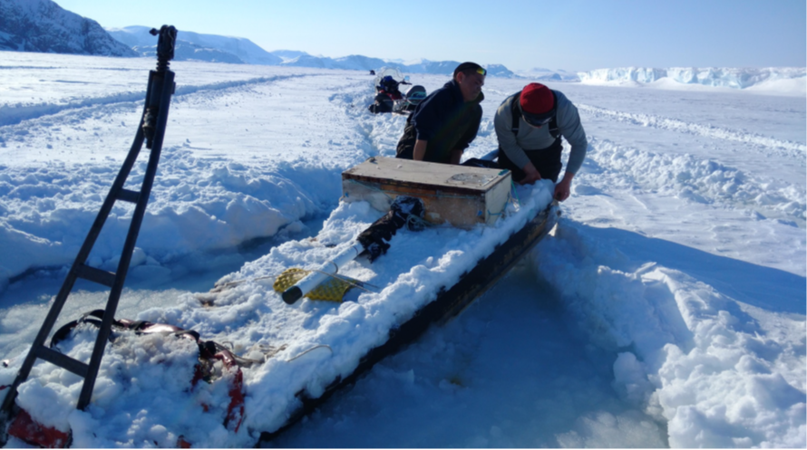
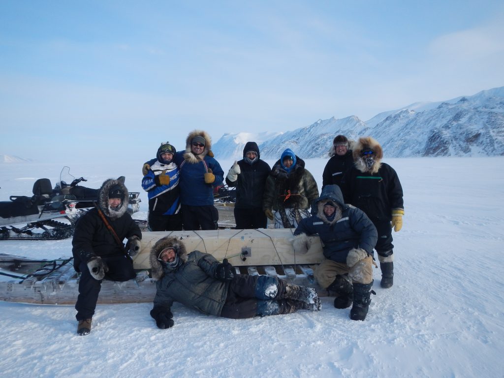
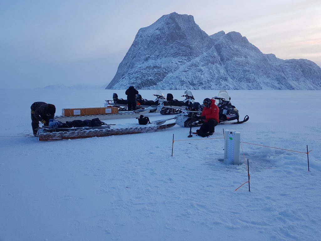
Project images
Summary
For Inuit, sea ice is a hunting platform, a travel highway, and part of our culture and identity. Changing climate is negatively affecting sea-ice characteristics that determine safe and efficient travel for Inuit, such as roughness, thickness, and slush. Consequently, there are increased travel accidents, search-and-rescue incidents, and impacts on mental health, food security, and cultural practices. Our Inuit-led project team will combine satellite data (optical and micro-wave frequencies), state-of-the-art uncrewed airborne vehicles (UAVs, or drones), and most importantly Inuit Qaujimajatuqangit (Inuit knowledge, values, and worldview) to co-produce new information on sea-ice roughness, snow roughness, and slush for SmartICE’s Sikumik Qaujimajjuti (community ice travel safety maps; see SmartICE.org). The production of these maps will be piloted in our partner communities and eventually expanded across Inuit Nunangat. Our approach will be grounded in Inuit Qaujimajatuqangit and include a co-designed Inuit training program for UAV-based sea-ice monitoring to augment the mature environmental data collection developed by SmartICE. With our Arctic Eider Society partner, Inuit Nunangat communities will be able to access in near real-time these new map products through the Indigenous Knowledge Social Network platform (SIKU.org).
Pour les Inuits, la glace de mer est une plateforme de chasse, une route pour voyager, et une partie de la culture et de l’identité inuites. Les changements climatiques ont un impact négatif sur des caractéristiques de la glace de mer qui sont déterminantes pour assurer la sécurité et l’efficacité des déplacements des Inuits, comme la rugosité, l’épaisseur et la présence de neige fondante. Il en découle donc une augmentation des accidents de voyage, des incidents de recherche et de sauvetage, ainsi que des répercussions sur la santé mentale, la sécurité alimentaire et les pratiques culturelles. Notre équipe de projet dirigée par des Inuits combinera des données satellitaires (fréquences optiques et micro-ondes), des véhicules aériens sans équipage (véhicules aériens sans pilote ou drones) de pointe et, surtout, l’Inuit Qaujimajatuqangit (connaissances, valeurs et vision du monde inuites) afin de coproduire de nouvelles informations sur la rugosité de la glace de mer, de la neige et de la neige fondue pour les Sikumik Qaujimajjuti (cartes communautaires de sécurité des déplacements sur glace; voir SmartICE.org) de SmartICE. La production de ces cartes fera l’objet d’un projet pilote dans nos communautés partenaires et sera ensuite étendue à tout l’Inuit Nunangat. Notre approche sera fondée sur les connaissances traditionnelles inuites et comprendra un programme de formation inuit conçu conjointement pour la surveillance de la glace de mer par drone, qui viendra s’ajouter à la collecte de données environnementales élaborées par SmartICE. Grâce à notre partenaire Arctic Eider Society, les communautés inuites du Nunangat pourront accéder en temps quasi réel à ces nouveaux produits cartographiques, par l’intermédiaire de la plateforme Indigenous Knowledge Social Network (SIKU.org).
Inungnut, taryum hikua anguniaqviuvaktuq, aullaaqtunut ingilraviuplui, ilauplunilu ilitquhiptingnut ilittuqhitiptingnullu. Aallannguqpalliayuq avatiit ihuilutauyuq taryum-hikuanut ilittuqhitiuvaktunik amirnaittumik ihuaqtumiklu aullaaqtunik Inungnut, taimaa maniilrunut, hilingnianut, hikuilruaniklu. Talvuuna, amigaiqpalliayut huliyuqaqtut aullaaqtunit, qiniqhiayut annaktillu havaaghainik, mihingnautillu ihumaqattiarniqmut, niqighaqattiarniqmut, ilitquhituqtunullu havauhiqnut. Inungnit-hivuliqtuqtauyuq havaqatigiit avugiingniaqtait satellite-kut naunaitkutat (tautughutik ungahiktukkuuqtullu naalautikkut), nutaatqiyanik aquyuqanngittunik tingmitjat (UAV-nguyut, tingmiyunnuilluuniit), aghuurnaqtukkullu taapkua Inuit Qauhimayatuqait (Inuit qauhimayatuqait, ikpigiyait, ihumagiyaillu) hanaqatauyaamik nutaanik naunaitkutaghanik taryum-hikua maniilruanik, aputimi maniilruit, hikuilruillu SmartICE-mut Sikumik Qauyimatjutit (nunallaarni hikumi aullaaqtut nunauyait; takulugu SmartICE.org). Hanayut hapkuninnga nunauyarnik hivuliqtuqtauniaqtuq havaqatiptingnit nunallaarnit hiamitiyaulutik Inuit Nunanganit. Havauhiqqut tunngaviqaqniaqtuq Inuit Qauhimayatuqanginnit iliqahiutilutik hanaqatauyunit hanahimayunik Inuinnarnit ilihaitjutighanik UAV-nit taryum-hikuanik munaqhiyunik ilauyughaq utuqqatqiyanut avatinut naunaitkutanut katitiqhimayut SmartICE-mit. Taapkualu Qingalingnut Katimayiit ikayuqtivut, Inuit Nunanganit nunallaat atuqtitauvangniat nutaanik tajja aulayunik naunaitkutanik nutaanit nunauyanit talvuuna Nunaqaqqaaqhimayut Qauhimayatuqait Inuit Tuhaatjutaigut (SIKU.org).
ᐃᓄᓐᓄᑦ, ᓯᑯ ᐊᓯᕙᕐᕕᐅᒻᑦ, ᐃᖏᕐᕋᕕᐅᒻᑦ, ᐱᖅᑯᓯᕆᓪᓗᓂᔾᔪᒃ ᑭᒃᑰᓂᖏᓐᓂᓪᓗ ᓇᓗᓇᐃᖅᓯᔾᔪᑕᐅᓯᓐᓈᖅᑐᖅ. ᐊᓯᔾᔨᐸᓪᓕᐊᓂᖏᑦ ᓯᓚ ᐊᑦᑐᐃᓂᖃᑲᒻᒪᒻᒪᑦ ᖃᓄᐃᑦᑑᓂᖓᓐᓂ ᓯᑯ ᐊᑦᑕᓇᕐᓂᖓᓐᓂᓪᓗ ᐃᖏᕐᕋᕕᐅᕙᑦᑐᓂᓗ ᐃᓄᓐᓄᑦ, ᒪᓃᑦᑑᒐᓗᐊᖅᑎᓪᓗᒍ, ᐃᔾᔪᓗᐊᓘᒐᓗᐊᖅᑎᓪᓗᒍ ᐊᕿᑦᑐᐊᓘᓪᓗᓂᓗ ᐃᒪᕈᔪᐊᓘᓪᓗᓂ. ᑕᐃᒪᓕ, ᐃᖏᕐᕋᔪᓂᒃ ᐱᕐᕈᓗᐊᕿᔪᖃᓐᓂᖅᓴᐅᓕᖅᑐᖅ, ᐸᕐᓴᐃᔩᓪᓗ ᐱᕐᕈᓗᐊᕿᓪᓗᑎᑦ, ᐊᑦᑐᐃᓂᖃᖅᑐᖅ ᐃᓱᒪᒃᑯᑦ, ᓂᕿᔅᓴᖃᕐᓂᒃᑯᑦ ᐱᖅᑯᓯᒃᑯᓪᓗ. ᐃᓄᓐᓄᑦ ᑲᒪᒋᔭᐅᓪᓗᑎᑦ ᐱᓕᕆᔪᑦ ᑲᑎᖅᓱᖅᓯᒪᔪᓂᒃ ᖃᖓᖅᑕᖅᑎᑕᐅᓯᒪᔪᒃᑯᑦ (ᐱᐅᔪᐊᓘᓪᓗᑎᑦ ᒥᑯᔪᐊᓗᓐᓂᑦ ᑕᑯᔪᓐᓇᖅᑐᑎᑦ), ᐱᐅᓂᖅᐹᒥᓪᓗ ᖃᖓᑦᑕᖅᑎᑕᐅᓯᒪᔪᓂᒃ (UAV, ᐅᕝᕙᓘᓐᓃᑦ ᖁᓛᒎᓕᓐᖑᐊᕐᓂᑦ ᐊᔾᔨᓕᐅᕆᖃᑦᑕᖅᑐᑎᑦ), ᐱᓗᐊᖅᑐᒥᓪᓗ ᐃᓄᐃᑦ ᖃᐅᔨᒪᔭᑐᖃᖏᑦ, (ᐅᑉᐱᕆᔭᖏᑦ ᓯᓚᕐᔪᐊᒥᓗ ᑕᑯᓐᓇᖅᑕᖏᑦ) ᐱᓕᕆᖃᑕᐅᓗᑎᒃ ᓯᑰᑉ ᒫᓃᓐᓂᐊᓗᐊᓂ, ᒪᐅᔮᓗᓐᓂᓪᓗ ᐊᕿᑦᑐᐊᓗᓐᓂᓪᓗ ᐃᒪᕈᔪᐊᓗᓐᓂᑦ ᖃᐅᔨᓴᐅᑎᒥᑦ SmartICE Inc. ᓯᑯᒥ ᖃᐅᔨᒪᔾᔪᑎᒥᑦ (ᓄᓇᓕᓐᓂ ᐊᑐᖅᑕᐅᕙᑦᑐᑦ ᐊᐅᓪᓛᖅᑐᓄᑦ ᓄᓇᓐᖑᐊᖑᓯᓐᓈᖅᑐᓂ; ᑕᑯᓗᒍ SmartICE.org). ᓄᓇᓐᖑᐊᓕᐅᓚᐅᖅᑎᓪᓗᒋᑦ ᐆᑦᑐᕋᐅᑎᐅᒐᔭᖅᑐᑦ ᐱᓕᕆᖃᑎᖃᕐᓗᑎᑦ ᓄᓇᓕᓐᓂ ᐊᒻᒪᓗ ᐊᖏᓪᓕᒋᐊᕐᓗᒋᑦ ᐃᓄᐃᑦ ᓄᓇᖓᓐᓄᑦ. ᑐᓐᖓᕕᖃᕐᓂᐊᖅᑐᒍᑦ ᐃᓄᐃᑦ ᖃᐅᔨᒪᔭᑐᖃᖏᓐᓂ ᐊᒻᒪᓗ ᐋᖅᑭᔅᓯᖃᓯᐅᔾᔨᓗᑕ ᐃᓄᓐᓂᑦ ᐃᓕᓐᓂᐊᑎᑦᓗᓂ UAV−ᒥᑦ ᓯᑯᓂᑦ ᐅᔾᔨᓱᕐᓂᕐᒥᑦ ᐊᖏᓂᖅᓴᓂᑦ ᐊᕙᑎᑦᑎᓐᓂ ᓄᐊᑦᑎᓇᓱᓐᓂᐊᕋᑦᑕ ᐊᖅᑭᔅᓱᐃᓗᑕ ᓱᑯᒥᑦ ᖃᐅᔨᓴᐅᑎᒧᑦ (SmartICE) ᐅᑭᐅᖅᑕᖅᑐᒥ ᑎᒥᐊᓄᑦ ᓴᓴᐃᔭᑎᒃᑯᖏᓐᓂ ᐱᓕᕆᖃᑎᖃᕐᓗᑕ, ᐃᓄᐃᑦ ᓄᓇᖏᓐᓂ ᐱᔪᓐᓇᖃᑦᑕᕐᓂᐊᖅᑐᒍᑦ ᓄᓇᓐᖑᐊᓅᕐᓂᐊᖅᑐᓂᒃ ᑐᓴᖅᑕᑎᓐᓂ ᓄᓇᓕᓐᓂ ᐃᓄᐃᑦ ᖃᐅᔨᒪᔭᑐᖃᖏᓐᓂ ᐃᓄᓕᕆᓂᕐᒧᑦ ᑲᒪᔪᓂᒃ (SIKU.org).
People
Principal investigators
Co-investigators and collaborators
-
Trevor Bell
Project point of contact
-
Robert Briggs
Collaborator
-
Rex Holwell
Co-Investigator
-
Emily Best
Communications

-
Eldred Allen
Co-Investigator
-
Becky Segal
Co-Investigator
-
Shawna Dicker
Co-Investigator
-
Randy Scharien
Co-Investigator
-
Monique Bernier
Co-Investigator
-
Saeid Homayouni
Co-Investigator
-
Emma Liu
Co-Investigator
-
Carl Thibault
Co-Investigator
-
Ilan Kelman
Co-Investigator
-
Katherine Wilson
Co-Investigator
-
Gillian Davidge
Co-Investigator
-
Lynn Moorman
Co-Investigator
-
Emma Dalton
Communications

-
Constanza Sofía Salvó
PhD Student
-
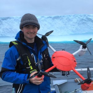
Mark Croke
Project Management

-
Grant MacDonald
Post-Doctoral Fellow
-
Thomas Newman
Post-Doctoral Fellow
-
Tom Johnson
PhD Student
-
Jimmy Poulin
Field Technical Support